What is there to see on Fuerteventura?
Fuerteventura is the second-largest Canary Island after Tenerife, with 1,659.74 square kilometres, according to English Wikipedia. Opening hours and entry prices for individual sites are unconfirmed, so check them with the operator.
This guide, correct as of Monday 2 November 2026, sorts the main sights by north, south and the island's centre. It also sets out the rules visitors should know.
Spanish Wikipedia gives about 326 kilometres of coastline, of which 77 kilometres is beach, while the English edition counts 152 beaches. Most sightseeing happens between La Oliva in the north, Betancuria inland and Pájara in the south.
The capital is Puerto del Rosario, one of six municipalities. The others are La Oliva, Antigua, Betancuria, Tuineje and Pájara.
UNESCO declared the entire island a biosphere reserve in 2009, as spain.info and Wikipedia both confirm. According to English Wikipedia, about 477 square kilometres lie in 13 protected areas.
Spain.info lists the Corralejo dunes with the Isla de Lobos and the Saladar de Jandía among them. It also names the Riscos del Carnicero, the palm grove in the Valle de Gran Tarajal and the Malpaís de la Arena.
Fuerteventura is also the oldest Canary Island, at about 20 million years, says Wikipedia. Tourism began in the 1960s with commercial air travel, according to Wikipedia.
The highest point, the Pico de la Zarza, stands in the Jandía massif. The Spanish edition gives 813 metres and the English one 807 metres, and it was not possible to establish which figure is official.
What do the Corralejo dunes in the north offer?
The Parque Natural de Corralejo covers 2,668.7 hectares, according to the state tourism site spain.info. It stretches south from Puerto Remedios in Corralejo to the Montaña Roja, a volcanic cone.
The dunes are among the island's most-cited sights, right next to the town where the Lobos ferries depart. Spain.info says visitors can reach them only from points along the FV-104 road.
Visitors must keep to the marked paths, the park's most important rule, because leaving them damages the fragile dune system. The marked access points on the FV-104 show the true extent of the walkable area best.
A German travel portal describes the dunes as about 11 kilometres long. That figure does not come from an official site, so treat it as a rough guide only.
How do you get to the Isla de Lobos and what does it cost?
Visitors need a free, personal and non-transferable permit for the Isla de Lobos from the Cabildo de Fuerteventura (the island government). The broadcaster RTVC says the Parque Natural Islote de Lobos was designated in 1982.
The booking portal Ferryhopper says you apply on the LobosPass site, separately from the ferry ticket. Entry without a permit is not allowed.
According to Ferryhopper, you can apply no earlier than five days before your visit. There are two four-hour slots, from 10:00 to 14:00 and from 14:00 to 18:00.
A commercial travel guide says no more permits are issued once the day's places are gone. Summer visitors should therefore apply on the first possible day.
In August 2025, about 1,200 visitors a day came to Lobos, three times the cap, says RTVC. The cap is 400 people a day in two shifts, according to RTVC, citing the management plan Plan Rector de Uso y Gestión.
Ferryhopper gives 200 people per shift, which adds up to the same daily limit. The Cabildo only considered a fee, the ecotax, in 2025, according to RTVC, and the permit remains free.
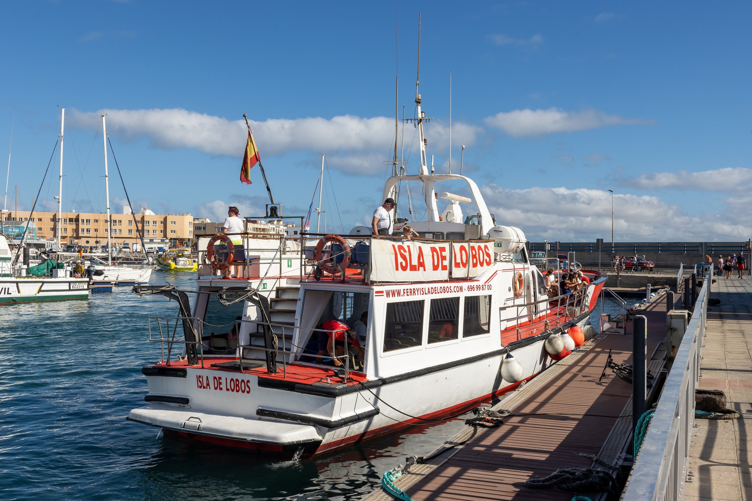
The ferry leaves from Corralejo and takes 15 to 20 minutes. Two operators run it: Isla de Lobos, at about 15 minutes, and Naviera Nortour, at about 20 minutes.
Ferryhopper lists up to 8 departures a day in high season. A commercial travel guide counts up to 5 sailings for Isla de Lobos and up to 3 for Nortour.
The sources contradict each other on prices. Ferryhopper lists tickets from 8.50 euros per adult, with no year given.
Another commercial portal gives 18 euros one way and 36 euros return, with children aged 4 to 11 paying 12 euros and under-4s travelling free. Neither figure comes from the ferry companies, so travellers should check the current price with the operator.
On 27 September 2026, RTVC reported that the Cabildo is stepping up monitoring and usage control in the park with a new Gesplan service. A budget of 277,434 euros is set aside, but RTVC says that is a total for several environmental projects and not for Lobos alone.
One travel portal puts the island at about 4.5 square kilometres, with a lighthouse, fishermen's huts and two restaurants. That is unconfirmed.
What is worth seeing in the south and the interior: Jandía, Cofete and Betancuria?
The Parque Natural de Jandía in the south has been a natural park since 1987, says Wikipedia. It includes the Playa de Cofete and the Pico de la Zarza.
The portal Picuco puts the Playa de Cofete at about 12 kilometres long, with the Casa Winter, dating from the 1940s, at its southern end. Opening hours and entry for the Casa Winter are unconfirmed.
The sources give no reliable information on getting to Cofete, so ask the car-hire firm and the local authorities beforehand. Beaches facing the open Atlantic are generally considered demanding, but there is no official statement on this here.
Betancuria became the island's capital in 1405, after Jean de Béthencourt's conquest, according to Wikipedia-based sources. Some sources also give 1404 as the founding year.
The town lies inland as protection against pirates, yet pirates destroyed it in 1593. It stayed capital until 1834, when Antigua took over.
These details come from summaries, not from an official source. Betancuria's old town has been a protected monument since 1979, according to Teneriffa-News.
The sources name the Iglesia de Santa María as a destination, and the area shows that Fuerteventura offers more than beaches. A travel blog says the Parque Rural de Betancuria covers 90 per cent of the municipality, but that figure is unconfirmed.
The Faro de la Entallada appears in the sources only as a cliff with Atlantic views. On history, a summary based on Wikipedia describes the Majoreros, the island's original people, as Berbers (Amazigh) of North African origin.
When is the best time to visit and what should you check beforehand?
Fuerteventura has an arid climate with a year-round trade wind from the east, according to travel portals. Wikipedia gives an average annual temperature of about 21.3 degrees, with summer highs of 27 to 28 degrees.
The coast often gets less than 100 millimetres of rain a year. Official monthly figures from the state weather service AEMET were not available for this research.
Travel portals put the water temperature at about 19 degrees in winter, about 21 degrees in summer and up to 23 degrees in September and October. The sun shines an average of about 7.7 hours a day.
These figures do not come from AEMET, so before a trip to the dunes, Lobos or Cofete, check the wind and weather report shortly beforehand. For current readings and warnings, see CITA weather (cita.news/en/weather.html) and AEMET.
During a calima, a hot, dry east wind carries Saharan dust, and temperatures can rise by up to 10 degrees, according to travel portals. The typical calima months are not documented in the research.
The island is in strong demand, says Canarian Weekly. Citing the island's tourism board, it reports tourism revenue above 3 billion euros for the first time in 2024.
Hotel occupancy averaged over 90 per cent, with peaks above 96 per cent in summer and December. Those travelling at such times should book accommodation and the Lobos permit early.
Fuerteventura is the second-largest island after Tenerife but only the fourth most populous, according to English Wikipedia. That explains the wide, sparsely settled landscapes.
The sources contain no sights on other islands, so they offer no comparison. Entry prices, opening hours, car hire, tours and parking rules remain open, so ask the operators.